Flood zone heats up

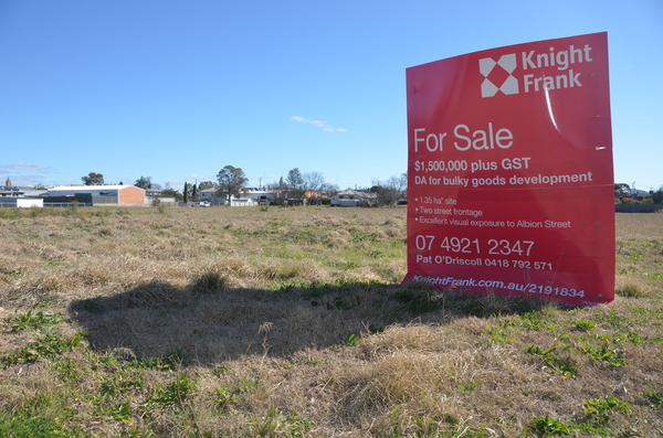
The proposed site for sale sits in a defined flood zone.

By DANE LILLINGSTONE

Concerns have been raised about flood zones after a 1.35 hectare piece of land went up for sale with development approval for bulky goods development.
The proposed site for sale, on the corner of Condamine and Canning streets in Warwick, is in the middle of the Flood Hazard Overlay Map released by the Southern Downs Regional Council in 2014 and based on 2013 data provided by the Department of Natural Resources and Mines Queensland 2013.
One resident contacted the Southern Free Times concerned that council were ignoring the past. In the 2011 floods his home was inundated with 8.35 metres of water.
The resident said it should be impossible for anyone to build-up land on the flood plain to protect them from flooding.
This particular piece of land, he says, would have had at least 1.5 metres of water during the 2011 floods.
Councillor Jamie Mackenzie said the land falls under the ‘Mixed Use’ zone under the Southern Downs Planning Scheme released in 2013.
“With its large site area and position behind highway developments, the subject land is therefore suitable for light industry and commercial warehouses,” he said.
“Under the Planning Scheme, there are a series of ‘Overlay zones’ and this site is shown in a flood area. Any development of the site needs to have floor levels well above the flood level with either a building on stilts or filled land or a combination of both.
”Perhaps the biggest concern for Southern Downs’ residents is that when the council’s planning scheme was released in 2013 some flood studies for areas in the region were not yet completed,” he said.
Cr Mackenzie said he objected to being a consultant on the plan at the time because of the uncompleted studies.
“Council at that stage had not completed flood studies for some catchments but from memory had done Warwick because it is a major issue. But for somewhere like Killarney, Council introduced a planning scheme that said development would be restricted in a ‘flood area’ that was not yet defined nor flood water depths established,” he said.
“Council has subsequently done the studies in other catchments and is moving to amend the Planning Scheme by including them. I support this to remove the uncertainties but would have personally preferred it to be done before the adopting of the Planning Scheme in 2013.”